Westech Inspection, Inc. employs trained FAA Part 107 licensed unmanned aerial systems (UAS) pilots who are also certified inspectors, including National Board (NBIC), API 510, API 570, API 653, and STI qualified personnel.
Because our drone operators are inspectors — not just pilots — collected imagery is evaluated with a full understanding of code requirements, damage mechanisms, and mechanical integrity programs. This allows us to provide meaningful inspection data rather than simple photography.
Our drone services support both industrial inspection and commercial imaging applications, including confined space inspection, remote visual inspection, indoor flight inspection, videography, photography, photogrammetry, and thermography.
Industrial Drone Inspections
Drone inspections represent a safer and more efficient method of evaluating difficult or hazardous locations. Using advanced indoor and outdoor UAS platforms, we can perform internal and elevated inspections without placing personnel in dangerous environments.
Typical applications include:
-
Tanks and pressure vessels
-
Stacks and towers
-
Roof and structural inspections
-
Elevated piping systems
-
Confined spaces
-
Areas requiring limited entry or scaffolding
Our FAA Part 107 pilots are also certified API and National Board inspectors, allowing inspection observations to be immediately interpreted within the context of applicable codes and standards.
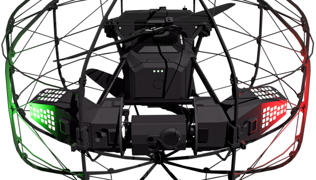
Confined Space & Indoor Drone Inspection
We utilize specialized indoor inspection drones designed specifically for enclosed industrial environments. These units operate at lower propeller speeds and produce minimal air disturbance, reducing dust and debris while improving image quality.
Features include:
-
Stabilized 4K visual camera
-
Integrated infrared (thermal) camera
-
Obstacle sensing and position-hold technology
-
Safe operation in GPS-denied environments
This technology allows internal visual inspections of tanks, vessels, and structures without requiring entry, improving safety while reducing downtime and confined space permitting requirements.
Photogrammetry & 3D Modeling
Photogrammetry converts photographs into measurable 2D drawings and accurate 3D models.
Using controlled flight paths and GPS-referenced positioning, we can generate repeatable models for documentation and condition monitoring.
Applications include:
-
Tank and structure dimensional documentation
-
Settlement and deformation tracking
-
Construction progress monitoring
-
Mapping and site documentation
-
Pre-project planning and engineering reference
Models can be reproduced during future inspections to track changes over time.
Thermography (Thermal Imaging)
Thermal imaging identifies temperature variations not visible to the naked eye, helping locate developing problems before failure occurs.
Common uses include:
-
Insulation failure detection
-
Refractory and heater hot spot identification
-
Electrical overheating detection
-
Process equipment monitoring
-
Energy loss evaluation in buildings and facilities
Thermography provides a non-contact method of detecting abnormal conditions while equipment remains in service.
Aerial Photography & Videography
In addition to inspection services, our pilots provide professional aerial photography and video documentation for:
-
Industrial facilities
-
Commercial properties
-
Real estate marketing
-
Agricultural applications
-
Construction documentation
We also provide professional editing and deliver clear, high-quality visual documentation tailored to your project needs.
Safer Access. Better Data. Faster Results.
By combining certified inspectors with advanced drone technology, we reduce the need for scaffolding, confined space entry, and production downtime while still delivering inspection-quality information suitable for maintenance and integrity decisions.